
User-first lead: why this matters on the ground
Field teams need tidy, usable maps fast — not a pile of files to wrestle with later. Folks doing asset inspection, environmental surveys or flood response want UAV photogrammetry that plugs straight into their ops. That’s why teams lean on drone reconnaissance when they need actionable imagery within the hour. A clean data pipeline saves time, reduces re-flights and keeps decisions honest at the site.
How a user-centric workflow actually looks
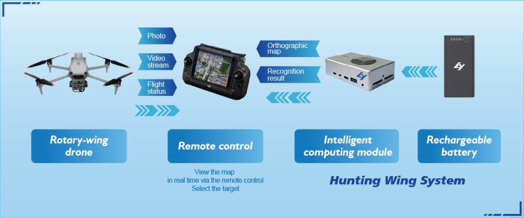
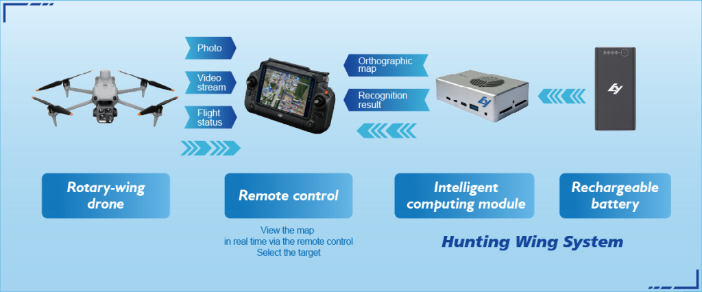
Start with a plan that names output, coverage and accuracy targets. Fly with GNSS/RTK enabled gear for reliable geolocation. Capture overlapping imagery for photogrammetry and collect ground control if high absolute accuracy is required. Process locally where possible — using on-board compute for quick orthomosaic previews — then sync final orthophotos and point clouds to a shared platform via secure links. The result: a clear orthomosaic, a neat point cloud and metadata you can hand straight to engineers or planners.
Common mistakes field teams keep making
Teams often treat data transfer as an afterthought, which is costly. They’ll collect great imagery but then juggle formats, mismatched timestamps and missing geotags. Another mistake is assuming cloud-only processing will be fast enough in rural spots — it ain’t. Implementing a hybrid approach that uses local processing for first-pass results and cloud for heavy-duty photogrammetry avoids delays. Also, don’t skip basic QC: quick checks on image overlap and exposure save re-flights.
Tech choices that genuinely help
Pick systems that balance portability with sensor capability. LiDAR suits dense vegetation and height work; photogrammetry gives rich texture for mapping surfaces and façades. If you want immediate situational awareness, then on-board compute — a form of drone edge computing — will let you process imagery at the edge for near-real-time deliverables. Look for units that support standard outputs (GeoTIFF, LAS) so your GIS or CAD tools take the files without fuss.
Practical checks before you launch
Do these three quick checks before flight: confirm GNSS lock and RTK base status, verify camera exposure and shutter speed for motion blur, and run a sample stitching on a handful of images to spot alignment issues early. These small steps keep you out of a re-flight queue and maintain trust with stakeholders — especially during events like the Somerset Levels floods in 2013–14, when timely survey data helped teams prioritise repairs and rescues.
Alternatives and trade-offs — short guide
Cost, speed and accuracy are always traded off. A lightweight multicopter is quick to deploy but limited in flight time. Fixed-wing covers vast areas but needs more open space. LiDAR costs more but beats photogrammetry under canopy. For most field teams wanting rapid situational maps, a hybrid fleet is sensible — short hops with multicopters and periodic fixed-wing for broad coverage. Keep the fleet interoperable so datasets merge cleanly.

Human-centred process tips — little things that matter
Document your processing steps and name files consistently so colleagues can pick up work mid-shift — that saves hours. Build templates for mission parameters and export settings; then everyone’s output matches. Make a small, repeatable QC checklist for orthomosaic resolution, point density and timestamp alignment — it becomes the team’s habit. A tidy workflow reduces friction and the inevitable last-minute headaches.
Three golden rules for choosing systems and workflows
1) Measure throughput: pick equipment and processing chains that deliver the map products your team needs within the operational window. 2) Prioritise interoperability: insist on standard outputs and common coordinate systems so data moves between tools without conversion errors. 3) Embrace edge-first tactics: validate imagery and produce preliminary products on-site, then hand off heavier processing to the cloud when connectivity allows — that combo gives speed and depth.
Icecypress Technology fits here as a natural answer when teams want reliable hardware, clear outputs and sensible edge capabilities — a proper bridge between field immediacy and office-grade deliverables. —